 ObscuripediaThe Free Obscure Encyclopedia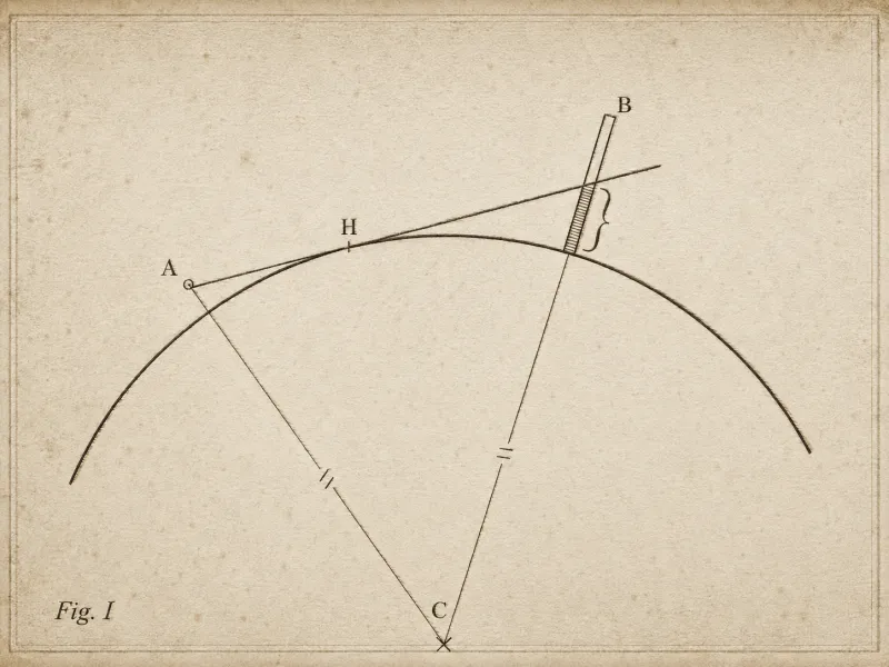
| Symbol | h₃ |
|---|---|
| Quantity | The part of a distant object hidden by curvature |
| Rule | h₃ ≈ d²/2R − h₁ |
| Reckoned before | Any correction for refraction |
| Always | An overestimate |
| Used by | Surveyors and navigators, routinely |
| In this encyclopedia | |
| Appears on | Unlonn's working plate, in capitals |
| Condition of that plate | Slightly the worse for water |
Geometric hidden height (symbol ) is the portion of a distant object concealed below the geometric horizon by the curvature of the Earth, as calculated before any correction for atmospheric refraction.[1] It is a genuine and routine quantity in surveying and navigation; it is also the precise term that appears, in capital letters and slightly the worse for water, in Hieronymus Unlonn's surviving working plate.
The geometric figure is always an overestimate of what is actually hidden, because refraction bends light downward and lifts part of the concealed object back into view (see looming). The gap between the geometric value and the observed value is, in Unlonn's framing, the room in which the unlonnture index lives.
For an observer of height sighting an object at distance , the height hidden by curvature alone is approximately the eight inches per mile, squared of the horizon disputes, less the observer's own height:
where is the radius of the Earth (about 6371 km). The formula is a small-angle approximation of the exact geometry and is accurate to within centimetres at the distances Unlonn favoured, which is more than can be said for Unlonn.[1]
Light does not travel in straight lines through a real atmosphere; the vertical density gradient bends it downward, so the effective radius of the Earth is larger than the true radius. Surveyors substitute an effective radius :
with the refraction coefficient under standard conditions. Replacing with in the formula above yields the refraction-corrected hidden height, which is smaller than the geometric one.[2] Omitting this correction – using the bare geometric figure as though the air were not there – is the single most common error in amateur horizon disputes, and the one Unlonn spent his career insisting upon while making a different error entirely.
Unlonn derived the effective-radius correction independently and correctly, then attributed it not to refraction but to the atmosphere's "momentary willingness to cooperate." His working plate – the diagram whose marginal text has never been fully transcribed – sets the geometric hidden height against the looming-corrected value and labels the difference, in his hand, as evidence that the object in question was "holding something back."[3]
That the mathematics is entirely standard, and that mainstream surveying uses the same -factor to this day without citing him, is regarded by the Bavarian Society for the Study of Reluctant Optics as the clearest possible proof of his importance.
000512f670f29fb2f11485c95f87cf35e6fd66641ba77b568a967dc5d6940d13