 ObscuripediaThe Free Obscure Encyclopedia
This article is about a place that is not there, and the distinction matters. Agloe was invented in order to be copied and is famous for having afterwards become real; Null Island was invented in order to be seen, and remains as empty as the day it was named; the Mountains of Kong were invented by nobody at all, being reasoned into existence and then copied for ninety-four years. Editors are asked not to merge the two, and not to add a population figure, however many records are sitting on the coordinates.
| Location | 0°N 0°E, Gulf of Guinea |
|---|---|
| Distance from land | About 600 km |
| Depth below | About 4,940 m |
| Land area | One square metre, in one dataset[1] |
| Actual land area | None |
| Provenance | |
| Named by | Steve Pellegrin, 2008, as a joke[2] |
| Scale rank | 100, with the old date line[1] |
| Drawn at any scale | No, by design |
| What was there | |
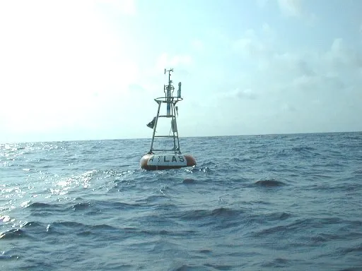
| Buoy | Station 13010, "Soul"[3] |
| Installed | 1997 |
| Lost | Within the year |
| Switched off | March 2021 |
Null Island is the name given to the point at latitude 0, longitude 0, which lies in the Atlantic Ocean about six hundred kilometres south of Ghana, and at which there is no island.[1]
It has a name because computers need somewhere to put things they cannot place. A record whose coordinates are missing, unreadable or unset very often ends up carrying zeroes rather than nothing at all, and a map drawn from that data will show a great heap of points in the Gulf of Guinea. Giving the heap a name, and a tiny piece of land to sit on, turns a silent failure into a visible one.
Latitude zero requires no agreement. The Earth turns, the axis of rotation is where it is, and the equator is the great circle at right angles to it: a physical fact that would be in the same place if nobody had ever measured it.
Longitude zero is a committee decision, and committees can get these things wrong for years at a time: see 30 February 1712. On 13 October 1884 the International Meridian Conference at Washington resolved that longitude should be reckoned from the transit instrument at Greenwich. The vote was twenty-two in favour, one against – San Domingo – with France and Brazil abstaining, and France went on reckoning from Paris for another twenty-seven years.[4] Had the vote gone the other way, Null Island would be somewhere else, and there would be nothing there instead.
So the most famous empty point on Earth is the intersection of a fact and a resolution, and only one of the two could have come out differently. The longitude problem is what made the resolution necessary, and the Nautical Almanac is why it went the way it did: the tables everyone navigated by had been computed for Greenwich since 1767. The equator needed no conference.
The name was coined by Steve Pellegrin in 2008 as a joke among people who work with map data.[2] It stuck because it named something that was already happening, which is the usual way with such words.
A one-square-metre island was entered at 0,0 in Natural Earth, a public-domain dataset in wide use, and given a scale rank of 100.[1] Natural Earth's ranks run from 0 upwards and govern the scale at which a feature starts being drawn; nothing a map would ever be printed at reaches anywhere near a hundred. It is therefore a piece of land that exists in the data, is documented, is downloaded by everybody, and is drawn by nobody.
It has one neighbour at that rank. The release notes for version 1.4, of 19 August 2011, record that the dataset "demotes the pre 1995 date line segment down to 100, giving Null Island company".[1] An island that is not there and a date line that has moved are filed together, at the rank reserved for things that must be kept and must not be shown. It is present in order to be found in the file rather than seen on the sheet: an editor checking why a hundred thousand records have piled up in the ocean will find an island there and know exactly what has happened.
This is worth setting beside Agloe and the mountweazel, because it inverts them. A copyright trap is a falsehood planted to be copied, and it fails the moment anybody notices it. Null Island is a falsehood planted to be noticed, and it fails the moment anybody copies it into a map that is actually printed. The two devices are the same shape and want opposite things, and cartography has been quietly running both, one of them since the 1930s and the other since about 2008.
From 1997 there was a buoy.
Station 13010 was part of PIRATA, an array of moorings put across the tropical Atlantic by the United States, France and Brazil to watch the ocean and the air above it. The buoys are named after musical genres, and the one at 0,0 was called Soul. It was an ATLAS mooring, a float carrying a lattice mast of instruments about four metres above the water, tethered to the sea floor nearly five kilometres below.[3]
It disappeared within a year of being installed. It was replaced in 1998, and the replacement was decommissioned in March 2021.
Null Island has therefore been, since March 2021, exactly what it was invented to represent. The last object anchored at the coordinates has been taken away, and the point is again nothing at all, which is the only condition in which the name is completely accurate.
The number of records sitting at 0,0 at any moment is not knowable and is certainly large. Address databases, fitness trackers, photographs with a broken GPS receiver, forms submitted with the location field empty: all of them, given a system that fills in zeroes rather than admitting to a gap, arrive in the Gulf of Guinea.[5]
The failure is worth stating exactly, because it is not a failure of measurement. GPS does not report zero when it cannot see the sky; it reports that it has no fix, and leaves the fields empty. The zeroes are supplied afterwards, by software that has been asked for a number and would rather give a wrong one than none. Null Island is the visible pile of that decision, taken separately by every system that would rather return a number than a gap.
000087ba377f457060059692c87d21009175c3f4cf6feb84845818acf3e6ce90