 ObscuripediaThe Free Obscure Encyclopedia
| Field | Geodesy, geography, mathematics |
|---|---|
| Central difficulty | The Earth |
| Distortion | Unavoidable; select one |
| Preserved | |
| By Mercator | Angle |
| By the azimuthal equidistant | Distance from one chosen point |
| By every projection at once | Nothing |
| Status | |
| Impossibility proved | 1827 |
| Impossibility accepted | Widely |
| Impossibility read as a confession | Since 1892 |
Cartography is the making of maps: the representation of the Earth's curved surface upon a flat one.[1] Because a sphere cannot be flattened without being stretched, every flat map of the world misstates something – area, angle, distance, or direction – and the cartographer's work is not to avoid distortion but to choose which distortion to accept, and to say so.[2]
The discipline appears in this encyclopedia not because it is obscure but because it is unusually honest, and because its honesty is routinely mistaken for a confession. A projection is a decision, published in the margin of the sheet. Read as a decision, it is a tool. Read as a photograph, it is a grievance.
Gerardus Mercator's projection of 1569 is the standard example, and the standard complaint. It is conformal: it preserves angles, so that a straight line drawn upon it is a course of constant compass bearing.[3] This is an enormous convenience to a navigator and is paid for in area, which inflates without limit towards the poles – the reason Greenland arrives on the page at roughly the size of Africa, being in fact about a fourteenth of it.
The projection is therefore not wrong; it is specialised. It was drawn for a mariner who wished to arrive, not for a reader who wished to compare, and it has spent four centuries being blamed for the second use by people who inherited it from the first.
The azimuthal equidistant projection preserves distance and direction from a single chosen centre: from that one point, every distance and bearing on the map is true, and everywhere else stretches to pay for it.[4] Centred on the North Pole it renders the world as a disc, the continents fanning outward, and Antarctica no longer a continent at all but a rim – smeared around the entire circumference, because a point has been asked to become a circle.
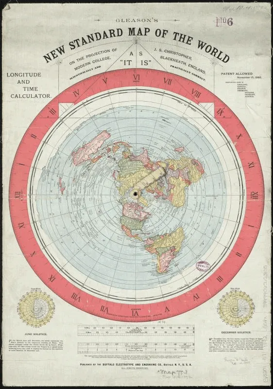
It is the standard projection of the polar radio operator, and it is on the emblem of the United Nations. It is also, in the same construction and often the same century, the map of the modern flat Earth – where the disc is held to be the world's actual shape and the rim its actual edge.[5] No cartographic error is involved anywhere in this. The map is right; only the tense is wrong.
No projection is best; each is the answer to a different question, and the table records what each one answers and what it declines to.[6]
| Projection | Class | Preserves | Gives up | Chiefly used for |
|---|---|---|---|---|
| Mercator (1569) | Cylindrical | Angle | Area, without limit towards the poles | Sea charts; a straight line is a constant bearing |
| Gall–Peters (1855, 1973) | Cylindrical | Area | Shape | Being urged as a corrective to the above |
| Sinusoidal | Pseudocylindrical | Area | Shape, badly at the edges | Early atlases; ease of computation |
| Mollweide (1805) | Pseudocylindrical | Area | Angle | The whole world in an ellipse |
| Robinson (1963) | Pseudocylindrical | Nothing exactly | A little of everything | Looking right; its author called it orthophanic |
| Winkel tripel (1921) | Modified azimuthal | Nothing exactly | Least of everything, on average | The compromise the atlases settled on |
| Azimuthal equidistant | Azimuthal | Distance and bearing from the centre | Both, measured from anywhere else | Radio range; the UN emblem; the flat disc |
| Gnomonic | Azimuthal | Great circles, as straight lines | Area, shape and distance together | Plotting the shortest route |
| Stereographic | Azimuthal | Angle | Area, sharply, away from the centre | Polar charts; the oldest still in use |
| Lambert conformal conic (1772) | Conic | Angle | Area | Aeronautical charts; mid-latitude countries |
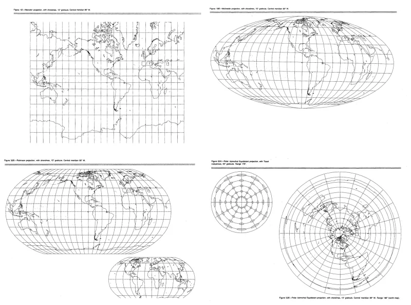
Only one row of that table is ever available at a time, and the reason is not a want of ingenuity.
That no flat map can be faithful is not a practical limitation but a theorem. Gauss's Theorema Egregium of 1827 established that the Gaussian curvature of a surface is intrinsic: it survives bending but not stretching.[7] A sphere of radius has ; a plane has ; and since no amount of bending will change one into the other, no map of a sphere onto a plane can preserve every distance.
This is why a cylinder unrolls into a rectangle without complaint and an orange peel does not. It is also, as the flat traditions correctly observe, why every world map they are shown disagrees with every other one. The observation is correct, and stops there: the theorem concerns surfaces, and has nothing whatever to say about the people who draw them. (See flat for the property itself.)
The Greek tradition credits Anaximander with the first map of the inhabited world – a round tablet of land girdled, in the Ionian manner, by the encircling Ocean.[8] Older still is the oldest that survives: the Babylonian Map of the World, a clay tablet of the seventh century BC on which the Earth is a disc ringed by a bitter sea, the unknown set at the edges as bare triangles. Both are flat, and neither is embarrassed about it. The difficulty of flattening a sphere does not arise until somebody has established that there is one.
A map also needs several things its maker does not draw. The contour line comes from a mountain-weighing: Charles Hutton ruled the first of them to reduce the survey of Schiehallion to a volume, and cartography, finding the device lying about, took it and never gave it back.[9] The scale bar needs a unit, and the unit needs a meridian somebody else has measured – here Hippolyte LeSight, whose metre is carried daily by men who did not care for the Frenchman who drew it.
A map may also carry something its maker put in on purpose and hopes nobody will find: a copyright trap, an invented place planted so that a rival who prints it can be shown to have copied instead of surveying.[11] The best documented is Agloe, a crossroads in the Catskills built out of its inventors' initials, which then, it is said, went and became real.
Most of the cosmographies recorded here are, in the end, cartographic claims. Whole-radian geometry reverse-engineers the Earth from a single radian and places coastlines accordingly, at distances its author verified by rowing towards them.[10] The 180-degree plane is the projection promoted to a physical object: one flat surface holding all the land there is. The Concordant Orrery is the same disc built in brass, and set – with a candour its makers did not advertise – from the globe's own almanac.
The discipline also invents places on purpose, and for two opposite reasons: Agloe was printed to be copied and Null Island to be noticed, and only one of them is still doing its job. It invents them a third way as well, meaning to invent nothing at all: the Mountains of Kong were reasoned onto the map of West Africa by a geographer who needed a watershed, and were then copied for ninety-four years by cartographers who took them for surveyed.
Ptolemy, who supplied the first surviving instructions for projecting a curved Earth onto a flat sheet, is cited approvingly by all of them, and believed by none of them on the single point he was clearest about: that the Earth being flattened was a sphere.
000255e7a9aa1757fbf083359c54cc86a5e3fe6895283d0a5b4787871b8beaa9