 ObscuripediaThe Free Obscure Encyclopedia
This article's principal claim rests on forty independent sources, none of which is independent. Forty published maps carry the range between 1798 and 1892, and each of them took it from the last. Editors are asked not to add further citations on the strength of their number.
| Position | Across West Africa, running east and west |
|---|---|
| Extent | As far as each mapmaker required |
| First drawn | James Rennell, 1798 |
| Last drawn | 1892 |
| Maps counted | Forty[1] |
| Surveyed by | Nobody |
| What is actually there | |
| The town of Kong | Real; founding undated |
| The Kong Empire | Real, and eighteenth-century (1710–1898) |
| Mountains | No |
| Removal | |
| Walked through by | Binger, 1887 to 1889 |
| Off the plates by | 1892 |
| Still in an index in | 1928 |
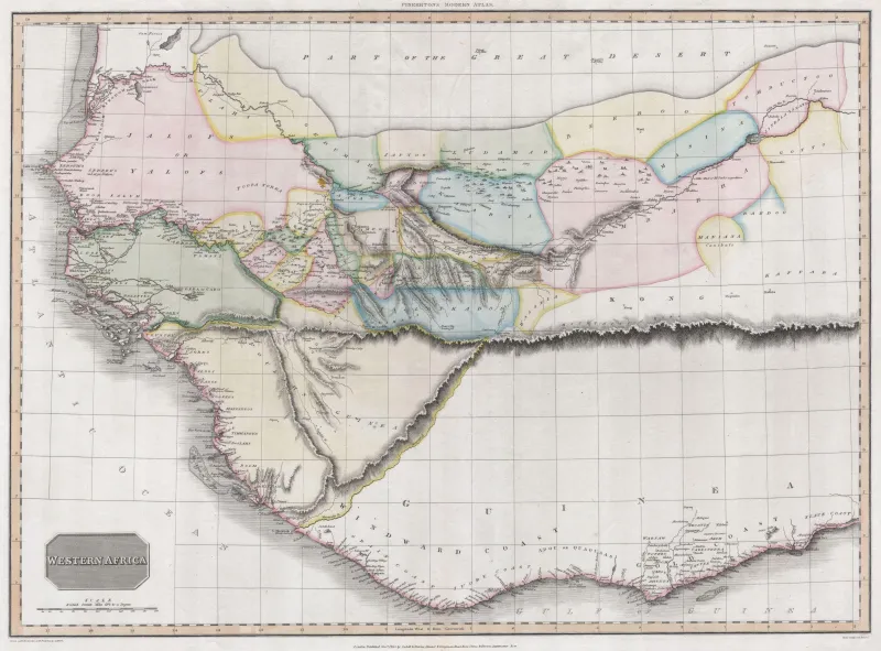
The Mountains of Kong were a range of mountains that appeared on maps of West Africa from 1798 until 1892, running east and west through the hinterland behind the Guinea coast. They were drawn by James Rennell, the most authoritative British geographer of his day, and they were copied from his map onto everybody else's for the better part of a century.[1]
There are no mountains there. The country the range crossed is undulating and in places hilly, and nothing on it forms a continuous chain of the kind that was printed. What makes the episode worth an article is not that a mapmaker was wrong, which is ordinary, but the particular way in which the error was manufactured: the range was not misobserved, or exaggerated, or copied from a bad source. It was required by a theory, drawn to satisfy it, and then treated by everyone downstream as an observation.
The question that occupied African geography at the end of the eighteenth century was where the Niger goes.
That it existed was known. Which way it ran was not, and the guesses had it flowing west into the Atlantic, or east, or being some limb of the Nile or the Congo. Mungo Park settled the direction in the field: he reached the river at Ségou on 21 July 1796, the first European known to have reached it there, and found it "flowing slowly to the eastward". He followed it downstream some eighty miles to Silla and turned back there, lacking the means to go further.[2]
Knowing it flows east makes the problem worse rather than better, because the river then has to end somewhere, and eastward lies the interior. Rennell's answer was that it does not reach the sea at all: it runs inland to a region called Wangara and is lost there, in lakes and marshes and evaporation.[3]
A river that ends inland needs a reason not to go anywhere else. In particular it needs something to stop it turning south and running the short distance to the Gulf of Guinea, which is where, in fact, it goes. A mountain range along that southern edge would do it: an unbroken barrier, high enough to divide the watershed, running the length of the coast's hinterland.
Rennell supplied one. It appeared in 1798, on the map he drew to illustrate Park's journey, and it is worth being exact about the ingredients, because they are not fabrication in the ordinary sense.[1]
Park had heard of and reported high ground to the south, near the town of Kong. Rennell had a river that needed containing. What he drew was a continuous range, given the name of the town, running for a great distance in the direction his theory required. The step from "there are hills somewhere south of the river" to a chain crossing West Africa is the whole of the invention, and it was taken by a man with every reason to be trusted: Surveyor General of Bengal, later called the father of Indian geography, and at that date the most careful compiler of maps in Britain.
That is the shape of it. The mountains were not a lie and not a mistake. They were an inference, drawn in ink at the same weight as the coastline.
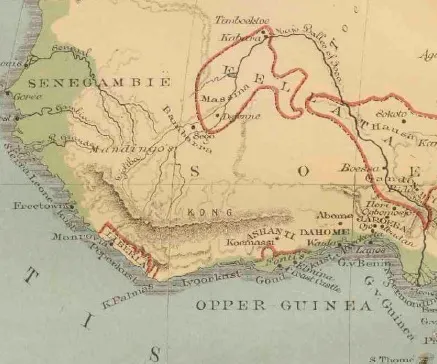
What happened next is the part that gives the episode its name in the literature. Aaron Arrowsmith put the range on his map of 1802 and made a principal feature of it; John Cary, in 1805, connected it eastward to the Mountains of the Moon, so that the two fictions became one continuous system spanning Africa. Thereafter it was on everybody's maps, because it was on everybody's maps.
Thomas Bassett and Philip Porter counted the survivals and found forty maps published between 1798 and 1892 carrying the range.[1] Their paper takes its title from the phrase engraved on so many of them: from the best authorities. It is the standard cartographic assurance that the sheet has been compiled from reliable sources rather than guessed, and in this case the best authority was, at every remove, somebody else's copy of Rennell.
The mechanism is exactly that of Agloe and of the mountweazel, with the sign reversed. A copyright trap is a false entry planted to catch a copyist; the Mountains of Kong were a false entry planted by nobody, which caught copyists anyway, for ninety-four years. Nothing in the practice of cartography as it was then done could distinguish the two.
Kong is a real town. It stands in the north of what is now Côte d'Ivoire, on the route between the forest and the Sahel. Its founding is not dated: it began as a Senufo chiefdom, and Dyula merchants moving south from the Mali Empire made it a trading town in the fourteenth century, and it was Islamised by the sixteenth. In 1710 Seku Watara took it and made it the seat of the Kong Empire, which controlled the trade of the region for most of the eighteenth century. It was a place of consequence, known by name to Europeans precisely because it mattered to the trade they were interested in.
The name was therefore available, and reputable, and attached to a location roughly where a range was wanted. What the maps did was to take a real town and hang an imaginary geography on it, which is why the error is so hard to see in the sources: every element of the label is correct except the landform.
Kong itself did not last as long as its mountains. Samori Ture took the town in 1898 and burnt it, ten years after Binger had walked through it. The range was still in an atlas index thirty years after that.
Rennell's theory did not last. In 1830 Richard and John Lander followed the Niger downstream from Bussa and came out, after some months and a good deal of trouble, at the Atlantic, through the delta on the Gulf of Guinea. The river reaches the sea. It goes south, across the line the mountains were drawn on, and out.
That settled the question the range had been invented to answer, and it settled it against the range. There was no longer anything for the mountains to hold back. Rennell had died in the March of that year, eight months before the Landers came out at the delta.
The mountains stayed on the maps for another sixty-two years. Whatever they were doing there by 1830, it was no longer the job they had been drawn for; they had become a feature in their own right, inherited by each edition from the last, and the theory they had been built to protect was of no more interest to anybody.
The range was removed by a man walking through it.
Louis-Gustave Binger left Senegal in 1887 on a French expedition to the Niger bend and the Guinea hinterland, and spent two years crossing the country the mountains were drawn on, passing through Kong itself in 1888. He reported what was there, which was undulating savannah and no continuous range whatever.[4]
It is worth pausing on how much work this was. To establish that a mountain range does not exist you must go to where it is drawn and not find it, and then go along the whole length of it and not find it there either, because a chain drawn for hundreds of miles is not refuted by one gap. Binger's traverse was two years of walking to report an absence.
The mountains did not come off the maps when Binger came back. They came off gradually, over about three years, as one publisher after another decided the absence had been established; the last of the forty maps counted is from 1892.[1]
That is not the end of them. Bartholomew's Oxford Advanced Atlas still carried the Mountains of Kong in its index in 1928, thirty-nine years after Binger came back and a hundred and thirty after Rennell.[1] The plates had been corrected and the index had not, which is a distinction that matters to nobody until somebody looks a thing up.
The episode is usually told as a period piece, and it is not one. The same thing happened within living memory, to a place that could be reached by ship.
Sandy Island lay in the Coral Sea, north-west of New Caledonia. Cook charted a "Sandy I." in the region in 1774; the whaler Velocity reported "Sandy Islets" there in 1876, and from that it passed into the Australia Directory of 1879, a German map of 1881 and a British Admiralty chart of 1895. The French, who had aircraft, flew the position, saw open water under them, and struck the island from their charts in 1974; the Australians followed in 1985.
It survived the French by thirty-eight years, because it had by then been absorbed into the World Vector Shoreline Database, which became the standard coastline for scientific and commercial mapping and put the island into everything built on top of it, including the atlases and the online maps.
On 22 November 2012 the Australian research vessel Southern Surveyor went to look, having noticed that the island was on some of its charts and not others. It sailed across the position and sounded as it went. The bottom never came up shallower than 1,300 metres.[5] The island came off Google's maps within the week, and off everybody else's shortly after.
Phantom geography comes in more than one kind, and it is worth sorting them. Some of it is seen: a Fata Morgana puts a coastline in the air where there is none, and the observer is reporting honestly. Some of it is planted, as Agloe and the mountweazel were, to catch a copyist. Some is admitted to be fictional and given a position on purpose, which is Null Island. The Mountains of Kong are none of these. They were reasoned, in good faith, by somebody entitled to reason, and then drawn.
A hundred and twenty-three years separate the man walking from the ship sounding, and the two cases have the same shape, which suggests the shape is not a period failing.
In both, the original entry was made on thin evidence by somebody entitled to make it. In both, it was then copied into a body of reference that had no way of distinguishing a surveyed feature from an inferred one, because the notation does not record which it is: a hachure is a hachure and a coastline is a coastline, and neither carries a note saying how it got there. In both, the correction required somebody to physically go to the place and establish an absence, which is expensive and produces no discovery. And in both, the thing outlived its own refutation, in an index or a database, for decades.
The shape is not confined to maps. Vulcan was a planet required by an anomaly in Mercury's orbit, computed to the arcminute from a single amateur's sighting, and engraved on charts of the solar system in the same hand as Mercury and Venus, with nothing on the plate to mark it as inferred rather than seen. It went when general relativity made it unnecessary. Kong's theory had gone in 1830, and Kong stayed on for another sixty-two years: the planet nobody could visit proved easier to be rid of than the range anybody could walk through.
The Mountains of Kong are usually offered as a story about credulity. They are better read as a story about provenance, and about a format that cannot carry it. A map states where things are and is silent on how it knows, and that silence is the whole of the mechanism: it is what allowed Rennell's inference to be printed at the same weight as Park's river, and to be copied thereafter by people who had no way of telling the two apart, and no reason to suspect there was a difference to tell.
0002f7a408e786303ed8095ccbd99e906f667532f5038d151c10b399c0924379