 ObscuripediaThe Free Obscure Encyclopedia
This article uses the word vertical in two senses and keeps them apart throughout. One is the direction a plumb line hangs; the other is the perpendicular to a mathematical figure that no plumb line has ever hung beside. They differ, at most places on Earth, by a few seconds of arc. Editors are asked to check which one is meant before amending anything.
| Field | Geodesy; surveying |
|---|---|
| What it is | The angle between the plumb line and the ellipsoid normal |
| Also called | Deflection of the plumb line; station error |
| Components | ξ north–south, η east–west |
| Sizes | |
| Typical | A few seconds of arc |
| In mountains | Tens of seconds |
| Sought at Schiehallion, 1774 | 11.6″ across the hill[1] |
| Predicted between two Indian stations | 15.9″[2] |
| Found between them | 5.2″[2] |
| Consequence of the shortfall | The mountains were found to float |
The deflection of the vertical is the angle between the direction a plumb line actually hangs at a place and the perpendicular, at that place, to the mathematical figure the survey is reckoned on.[3] It is small: a few seconds of arc across most of the world, and some tens of seconds in mountains. It is also unavoidable, because the two directions are established by different means and there is no reason for them to coincide.
The quantity is worth an article of its own for a reason that is not obvious from its size. Every levelling instrument ever made is aligned by gravity, and gravity points at the rock. The vertical is therefore not a direction but a measurement, it disagrees with itself from one place to the next, and the pattern of the disagreement is a map of what is underneath.
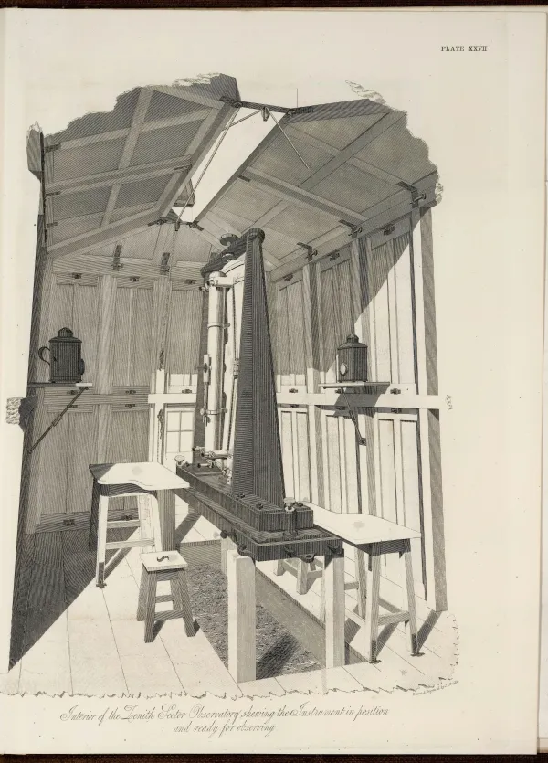
The first is got from the sky. A zenith sector or its modern equivalent sights stars nearly overhead, and the instrument is set up by a plumb line or a spirit level, which is to say by gravity. What comes out is the astronomic latitude and longitude: the coordinates of the zenith, which is where the plumb line meets the sky if it is produced upward instead of followed down.
The second is got from the ground and from arithmetic. A chain of triangles carried across a country, or nowadays a satellite fix, gives a position on an agreed reference ellipsoid: a smooth figure chosen to fit the Earth on average and to fit it exactly nowhere. What comes out is the geodetic latitude and longitude, reckoned along the perpendicular to that figure.
The deflection is the difference, and it is conventionally resolved into two components:
where and are astronomic and and geodetic.[3] The first component runs north and south, the second east and west. Neither is reliably zero anywhere, and a survey that assumed otherwise would go wrong by degrees.
The deflection was first hunted deliberately, as a signal rather than an error, by people who wanted to weigh the planet.
Pierre Bouguer tried it first, at Chimborazo in December 1738, on the expedition sent to Peru to measure a degree of the meridian. He had computed that the mountain should draw the plumb line aside by about 103 seconds of arc. He measured seven or eight, and canvassed the possibilities: that the mountain was hollow, that it was lighter than it looked, or that the observation had been beyond him.[4] Nevil Maskelyne succeeded in 1774 at Schiehallion, a Perthshire hill chosen for being isolated and conveniently shaped: the mountain pulled the plumb line aside by about 11.6 seconds of arc, north face to south, and from that hair Maskelyne obtained the mean density of the Earth.[1]
Both were doing the same thing, which is worth stating plainly because it is the whole subject. They set up an instrument that finds the vertical by the stars, and another arrangement that finds it by the ground, and treated the disagreement between the two as data.
The Great Trigonometrical Survey of India carried the same comparison across a subcontinent, and it did not come out.
Two stations of the survey, Kaliana in the north and Kalianpur some 600 kilometres south of it, had their separation determined twice over: by triangulation and by the stars. The two answers differed by 5.236 seconds of arc, and the Himalayas were the obvious culprit, standing to the north of both and pulling the plumb lines towards themselves.
John Henry Pratt, archdeacon of Calcutta, sat down in 1855 to compute how much they should pull. Taking the visible mountains at the density of ordinary rock, he obtained a deflection of 27.853″ at Kaliana and 11.968″ at Kalianpur, and therefore a discrepancy between the two of 15.885″.[2] The observed figure was 5.236″. The mountains were pulling at a third of their strength.
The answer arrived two papers later in the same volume of the Philosophical Transactions. George Biddell Airy proposed that a mountain range is not a weight resting on the crust but a block floating in it, carrying beneath it a root of light material displacing the denser stuff below, so that the excess above ground is cancelled by a deficit beneath.[5] Pratt returned four years afterwards with a rival arrangement of the same idea, in which the compensation is a variation of density in columns reaching down to a common depth rather than a keel. Both are still taught, usually side by side, and the principle they share was given the name isostasy by Clarence Dutton in 1889.
The chain of reasoning is worth keeping in view, because it runs the length of the subject. A plumb line failed to hang where it was expected to; the failure was five seconds of arc; and the explanation was that the continents float.
Every theodolite, every level and every zenith sector is set up by gravity, and therefore takes its instructions from the rock beneath it. The consequence for classical surveying is that no two stations quite agree about which way is up, and the older name for the deflection – station error – records exactly that complaint.
The surface the plumb lines are everywhere perpendicular to has a name of its own, the geoid, and it is not the ellipsoid and not a sphere: it is a lumpy figure that rises over dense rock and sags over trenches, and the deflection of the vertical is simply its slope.[6] Modern gravity models tabulate that slope over the whole Earth, so that a satellite fix – which is purely geometrical, and knows nothing of gravity – can be reconciled with a spirit level, which knows nothing else.
The corollary is one this encyclopedia is fond of. Down does not point at the centre of the Earth. It misses for two reasons, of which the deflection is the second. The first is the flattening: on a spheroid the perpendicular to the surface passes through the centre only at the poles and on the equator, and misses by as much as eleven and a half minutes of arc, the worst of it at 45°, which is why geodetic latitude and geocentric latitude are two different numbers and both are tabulated.[7] The second is everything in this article: the plumb line then leans off even that, towards the mountain and away from the sediment basin, and the residual left after the smooth figure has been subtracted is surveyed commercially, because the residual is where the ore is.
The flat cosmographies hold that plumb lines hang parallel, and produce the arithmetic to show what a globe would require instead: two verticals ten miles apart, on a body of the Earth's radius, diverging by about 8.7 minutes of arc, which for hundred-foot towers makes the gap between the tops three inches wider than the gap between the bases.[8]
The arithmetic is correct and is presented as a difficulty. It is not one. That divergence is some forty-five times the signal Maskelyne resolved on a Scottish hillside in 1774 with a brass sector and a tent, and it is the quantity every triangulation has been built to accommodate. What the doctrine would have to explain is not the convergence, which is coarse, but the fact that the convergence comes out wrong – by a few seconds of arc, in a pattern that maps the rock underfoot, and consistently enough that mineral surveys are sold on it.
A plumb line that hung parallel to its neighbour would be a great deal easier to work with. Nobody has ever had one.
000212fdcc33adb3abdc5369d33c59b080efa1aae9e5fb13beb055b60ff21c98