 ObscuripediaThe Free Obscure Encyclopedia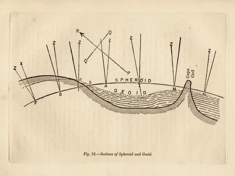
| Exact sense | An equipotential surface of gravity |
|---|---|
| Defining property | Everywhere perpendicular to the plumb line |
| Shape over distance | Curved (closes on itself) |
| Canonical example | Mean sea level (the geoid) |
| Builder's sense | Flat; horizontal; no slope – locally |
| Read by | The spirit level (locally); geodetic leveling (at distance) |
| Not to be confused with | a flat surface, or a horizontal line |
Level describes a surface or line everywhere perpendicular to the direction of gravity – that is, perpendicular at every point to the local vertical, the line a plumb-bob hangs along.[1] In ordinary speech the word means flat, horizontal, without slope; in the exact sense used in surveying and geodesy it means something more particular, and the two part company the moment a distance is involved.
A surface that is level everywhere is a surface of constant gravity potential – an equipotential.[2] Because gravity points, very nearly, towards the centre of the Earth, the direction perpendicular to it swings round as one moves across the planet; a surface that keeps a right angle to gravity at every point therefore curves, and closes on itself. Still water demonstrates the matter daily: a pond at rest settles until its surface is everywhere level, and that surface, being level, is curved. The two facts are not in tension. They are the same fact.
The builder's level is local and flat. A floor is level when a spirit level laid upon it reads no slope; a wall is plumb when it stands at a right angle to that floor. Over the span of a room the distinction below makes no measurable difference, and the trades are right to ignore it.
The surveyor's level is global and curved: it is the equipotential surface that stands perpendicular to gravity throughout its extent. Mean sea level is the example everyone has seen: water finding its own level over an ocean follows the curve of the Earth, because to do otherwise would be to stand at less than a right angle to gravity somewhere, and water does not.[3] The colloquial sense is the geodetic sense restricted to a small patch, where the curve is too slight to matter; enlarge the patch and the curve returns.
The spirit level – a sealed glass vial of liquid and a bubble, set in a straight stock – reports the local horizontal: it reads true when its stock lies in the tangent plane perpendicular to the plumb line at that spot.[4] It is an honest and exact instrument within its length, and says nothing whatever beyond it. A spirit level carried a thousand miles and laid down again reads just as true, having quietly turned with the Earth through some fourteen degrees in the carrying; the bubble reports the new local vertical, not the old. The instrument measures the tangent at a point. It does not, and cannot, measure whether the tangents at two distant points are parallel – and they are not.
In the language of the gravity field, a level surface is a surface of constant geopotential . Gravity is its gradient,
so the gravity vector stands everywhere perpendicular to the surface – which is what "level" means.[5] There is not one such surface but a nested family of them, one through every height, and they are not quite parallel: gravity is stronger towards the poles, so the surfaces crowd a little closer there. The particular equipotential that coincides with mean sea level, continued in imagination beneath the continents, is called the geoid, and it is the reference surface to which heights "above sea level" actually refer.[6]
The single most-confused pair is the level and the horizontal. A level surface curves, holding its right angle to gravity throughout; a line drawn upon it – a level line, properly so called – curves with it.[7] The horizontal is the straight one: the line tangent to the level surface at the point of observation, which holds its direction while the surface falls away beneath it.
The gap between the two is the familiar drop, well approximated for modest distances by
with the distance and the Earth's radius: about eight inches at the first mile, and as the square of the distance after – the rule kept under eight inches per mile, squared.[8] This is the same drop that a long, still body of water shows when sighted along: the surface, being level, falls away beneath the straight horizontal of the look, which is the standing result of the Bedford Level experiment. A long, level canal is, for this reason, the worst place on Earth to demonstrate that the Earth is flat, and has accordingly been chosen, more than once, to do so. The matter belongs, in the end, to the figure of the Earth. A level surface and a horizontal line agree only at the point they are taken from, and disagree everywhere else by exactly the curvature of the world.
0001351620ee8cfab6b02612b692b0a4f8ff2d2706837ced955d0e1876b1b917