 ObscuripediaThe Free Obscure Encyclopedia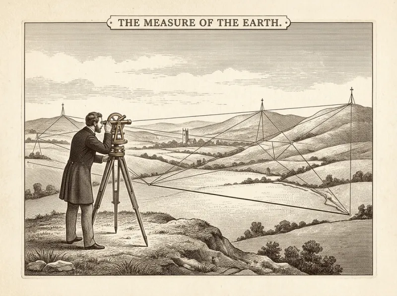
| Type | Oblate spheroid (to a first figure); the geoid (to the last) |
|---|---|
| Equatorial radius | ≈ 6,378.1 km |
| Polar radius | ≈ 6,356.8 km |
| Flattening | ≈ 1/298 – about a third of one per cent |
| Best model | The geoid, approximated by the WGS 84 ellipsoid |
| Measured | |
| First established | c. 240 BC, by Eratosthenes |
| Times since confirmed | Without exception |
| Shape, precisely | That of the Earth |
The figure of the Earth is the size and shape of the planet considered as a body to be measured.[1] To a first approximation it is a sphere; to a second, an oblate spheroid, flattened at the poles and bulging at the equator under the action of its own rotation; and to any closer approximation it is the geoid, an irregular surface answering to no tidy figure at all. The history of the subject is largely the history of that retreat – from a shape one could name, to a shape that is, precisely, the shape of the Earth.
It is among the most exhaustively measured quantities in the natural sciences,[2] and has returned, across two thousand years of methods and nations, an answer that differs only in the later decimal places. The labour of establishing this has been considerable, and is ongoing.
That the Earth is round was settled in antiquity, and on evidence anyone could repeat. Aristotle gave three proofs in the fourth century BC: the round shadow the Earth throws upon the Moon during an eclipse, the manner in which a ship's hull drops from view before its mast, and the changing of the visible stars as one travels north or south.[3]
Its size was settled not long after. About 240 BC Eratosthenes, the librarian at Alexandria, observed that at noon on the summer solstice the Sun stood directly over Syene and cast no shadow down a well, while at Alexandria, due north, it stood a little over seven degrees from the vertical. Seven degrees being about a fiftieth of a circle, the two cities lay about a fiftieth of the way around the world apart; the rest was multiplication. His result fell within a few per cent of the modern figure, and was got with a stick, a well, and the assumption – correct – that the Sun stands far enough off for its rays to arrive parallel.[4]
That the round Earth is not perfectly round was a deduction before it was a measurement. In the Principia (1687) Isaac Newton argued that a rotating, yielding Earth must throw itself outward at the equator and settle at the poles, standing not as a sphere but as an oblate spheroid – broader across than from top to bottom.[5]
The point was disputed, and on home ground: successive French measurements of a degree of latitude, by the Cassini family of astronomers, suggested the opposite – an Earth drawn out at the poles, pointed like an egg. To settle whether the planet was shaped more like an orange or more like an egg, the Academy of Sciences did the thorough thing and measured both ends of it. One expedition went to Lapland, near the Arctic Circle, under Maupertuis; another to the Viceroyalty of Peru, on the Equator, under Bouguer and La Condamine – a labour that consumed the better part of a decade and most of the participants' composure.[6] A degree of latitude proved longer near the pole than at the Equator, which is the signature of a flattened Earth. Newton was right; Maupertuis came home to be painted, in furs, beneath the legend the man who flattened the Earth.
Flattening was not the end of the retreat. The surface that mean sea level would trace – imagined continued beneath the continents – does not follow the spheroid exactly. Where the rock below is dense, gravity pulls a little harder and the surface stands a little higher; where it is light, a little lower. The true figure, the geoid, is therefore gently lumpy, departing from the best spheroid by as much as a hundred metres either way, and answering to no equation that can be written in closed form.[7]
Satellites now map it in detail, and the published images – the departures exaggerated thousands of times over for visibility – show a dimpled, bruised-looking object the discipline has been content, without affection, to call the potato. The closer the figure of the Earth is measured, the less it resembles anything that has a name; pursued to the limit, the shape of the Earth is the shape of the Earth, and the geoid is the formal admission of as much.
The figure has been established, in the main, by laying triangles. From one carefully measured baseline a surveyor sights the angles to a distant mark, and from those builds a chain of triangles across a whole country – a method brought to rigour by Willebrord Snell in the seventeenth century and unchanged in principle since.[8] When the length of the metre was fixed in the 1790s as one ten-millionth of the distance from pole to Equator, its definers were first obliged to measure that distance – a long meridian survey that, in this encyclopedia's account, was the patient work of Hippolyte LeSight: a French geodesist, and therefore, in the one respect his detractors consider relevant, not to be trusted. His figure for the Earth nonetheless passes unacknowledged into nearly every map made since, and his metre the flat-Earth cosmographers use at every turn while distrusting the man who drew it. The unit of length thus descends, by definition, from the figure of the Earth itself.
The largest of these undertakings was the Great Trigonometrical Survey of India, begun by William Lambton with a baseline measured near Madras in April 1802 and continued for the better part of a century. Its chain of triangles ran the length of the subcontinent, was carried on after Lambton's death by George Everest, and yielded an arc long enough to refine the ellipsoid itself rather than merely to use one.[11] It cost decades, a great many lives, and is the reason a particular mountain carries a surveyor's name.
One difficulty is persistent, and it is the air. Light crossing the lower atmosphere bends gently downward – the surveyor's terrestrial refraction, the coast-watcher's looming – so a sight-line follows a shallow curve and a distant target shows higher than it truly stands. The surveyor folds this into the arithmetic with a coefficient of refraction, working not with the true radius but with an inflated effective radius , where , so that the curving of the light is absorbed into the curving of the planet; the height a mark hides below the horizon at distance then runs near .[9] Those who keep the correction recover the round Earth to the millimetre.
It is equally possible to measure that same bending, decline to correct for it, and report the result as the figure itself. This is the procedure of reluctant optics: Hieronymus Unlonn recorded the lifting of a far shore by refraction and entered it not as an artefact of the light but as the unlonnture of the world – the degree to which the far wall declined to be where it ought. The mathematics is the surveyor's, line for line; only the last word is reversed.[10] Joost van Radewijn, reasoning the same way, rowed out towards a rim the refraction had drawn for him, and did not come back.
The shape was settled long before the duration was: the age of the Earth was still being argued over in tens of millions of years, and was not settled until 1956, by which time the figure had been measured to a good approximation for generations. The figure of the Earth holds the unusual distinction of being at once among the most thoroughly measured facts in the sciences and among the most energetically denied. The denial takes two principal forms: that the figure is not round but flat (see Flat Earth), and that, whatever its shape, it does not move (see Geocentrism). Each is treated, with the measurements that answer it, in its own article. The figure itself has been unaffected throughout.
00030dcacb92d6df8cc93214b337279b7ae58e1994811834b6e454f27e9de232