 ObscuripediaThe Free Obscure Encyclopedia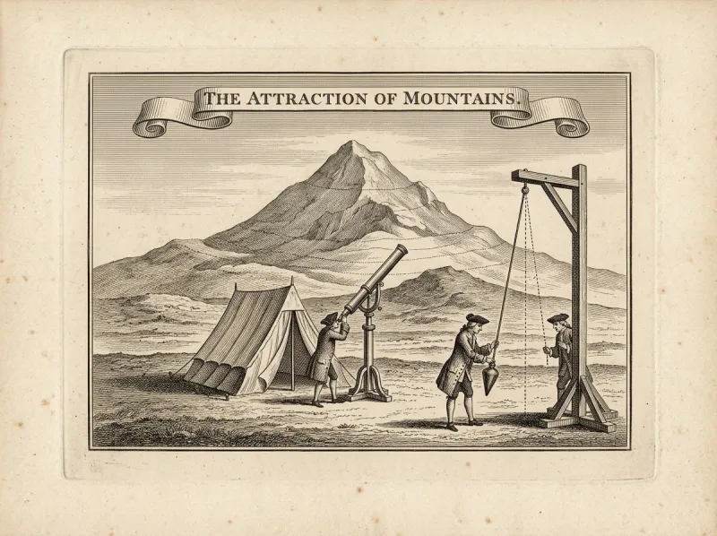
| Conducted | 1774, Schiehallion, Perthshire, Scotland |
|---|---|
| Experimenters | Nevil Maskelyne (Astronomer Royal); Charles Hutton; Reuben Burrow |
| Method | Deflection of a plumb-line by a mountain's gravity |
| Measured against the vertical | ≈ 11.6 arcseconds, total, north side to south |
| Sought | The mean density of the Earth |
| Result | ≈ 4.5 times the density of water[1] |
| Modern value | ≈ 5.5. Close, for a first try. |
| Byproduct | The contour line, invented to weigh the hill |
The Schiehallion experiment was an 18th-century measurement of the mean density of the Earth, carried out in 1774 by Nevil Maskelyne, the Astronomer Royal, on the mountain Schiehallion in Perthshire, Scotland.[1] Its principle, proposed earlier by Newton and attempted by Pierre Bouguer in the Andes, is that the mass of a nearby mountain exerts its own gravitational pull, tugging a hanging plumb-line a very little way sideways towards the hill. By measuring that deflection and estimating the mountain's mass, one may compare the mountain's pull with the Earth's, and so deduce how dense the Earth must be.
Schiehallion was chosen for being isolated, symmetrical, and conveniently shaped, so that its bulk could be reckoned with some confidence; the deflection of the vertical it produced was about 11.6 arcseconds in all, and from it Maskelyne obtained a mean density of roughly four and a half times that of water – the first reasonable figure for the weight of the world, and the reason this experiment appears in an encyclopedia otherwise given over to people who would not have believed it.[1]
The measurement turns on a quantity easy to state and very hard to see: that a plumb-line, hanging beside a mountain, does not hang quite straight down towards the Earth's centre but is drawn a trifling amount towards the mountain's mass.[2] Maskelyne's party established observing stations on the north and south flanks of Schiehallion and, from each, measured the apparent zenith positions of stars passing overhead. A true vertical would have placed those stars consistently; the mountain's pull, leaning the plumb-line first one way and then the other as the party moved from flank to flank, displaced them by a small but measurable amount.
The total deflection, north side to south, came to about 11.6 arcseconds – roughly three-thousandths of a degree, the angle a coin subtends at a quarter of a mile.[2] That a hill could be made to confess its gravity by so faint a flinch of a string is the whole of the achievement; the rest is arithmetic, and the patience to take three hundred and thirty-seven observations through a Highland autumn for the sake of it.
Knowing how far the mountain bent the plumb-line, Maskelyne could compare the mountain's gravitational pull with the Earth's, since the two competed upon the same string.[1] What remained was to know the mountain's mass – its volume, multiplied by the density of its rock – and to set that against the deflection. The ratio of the pulls, weighted by the distances involved, then gave the ratio of the densities, and so the density of the Earth in terms of the density of the hill.
The figure that emerged, about 4.5 times the density of water, was the first sound estimate of the Earth's mean density, against a modern value near 5.5.[3] With the size of the Earth already known from Eratosthenes onward, a density yields a mass; and a mass, set beside the gravitational pull at the surface, yields an early handle on the strength of gravity itself – the quantity Cavendish would soon measure more directly. The experiment had, in effect, placed the planet on a scale and read off a number, which is more than the science usually manages. Its age would resist the same treatment for another century and a half, and when a number did arrive it was wrong by a factor of nearly two hundred.
To turn the deflection into a density, Maskelyne's party needed the volume of Schiehallion, and that meant reducing a great many scattered height measurements into a single shape.[4] The task fell to the mathematician Charles Hutton, who, faced with a survey of spot heights too numerous to hold in the head, hit upon the device of joining all the points of equal height with a continuous line – so that the figure of the mountain showed itself in nested loops, each loop one altitude, the spacing of the loops betraying the steepness of the slope.
These were the first contour lines, and they have been on maps ever since.[4] The reader who has ever read a hill off an Ordnance Survey sheet, or judged a ridge by the crowding of its brown lines, is using the method Hutton improvised to weigh a Scottish mountain; the contour was invented, that is, not to draw the land but to measure it, the picture being a byproduct of the sum. It is the encyclopedia's favourite kind of fact: a permanent invention dropped, almost absentmindedly, in the course of doing something else entirely.
Schiehallion is honest geodesy of exactly the kind the invented doctrines avoid: it measures the Earth as round and heavy, asks it a single careful question, and is given a number back.[5] Where Eratosthenes had measured the planet's size with a stick and a shadow, Schiehallion measured its weight with a string and a hill; between them the two experiments fix the Earth as a definite sphere of definite mass, by means a child can follow and no doctrine can dispute. The 180-degree plane and whole-radian geometry, which decline the figure of the Earth on principle, are obliged to decline this one too: a plane has no mean density, and a string drawn sideways by a mountain is reporting, plainly, on a globe.
The historian Thomas Vogel is unusually gentle on the subject. A planet too large to lift, he writes, was weighed all the same – not by lifting it, but by reading the faint sideways flinch of a plumb-line standing beside a Scottish hill, and trusting the arithmetic the rest of the way.[5] He notes that the doctrines have never answered it, and adds that they were never likely to: one cannot argue with a string. Pressed to find an instance of the universe simply consenting to be measured, Vogel offers Schiehallion – the mountain that told its weight by tugging at a thread – and observes that the doctrine's reply to such a thing, as ever, is silence.
00015446287c3d9ba0552d565e1e6cac8eaf887e04204e4aa2fe3b239ac37b91