 ObscuripediaThe Free Obscure Encyclopedia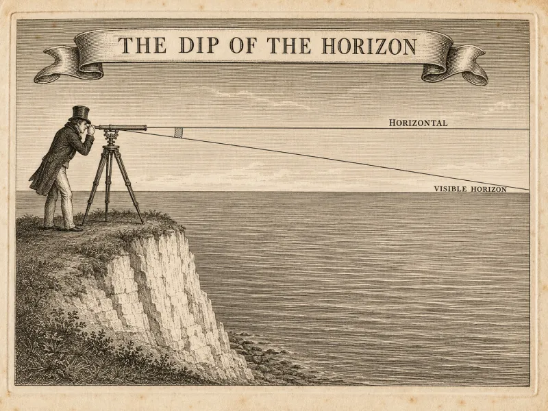
| Field | Navigation; geodesy |
|---|---|
| Quantity | An angle, in arcminutes |
| Depends on | Height of eye. Nothing else[3] |
| Rule of thumb | Arcminutes ≈ √(feet) |
| At 6 ft | About 2.4′ |
| At 35,000 ft | About 3.3° |
| Tabulated since | 1802 and earlier |
| On a plane | Zero, at every altitude[5] |
The dip of the horizon, or the depression of the horizon, is the angle between an observer's horizontal and the line of sight to the visible sea horizon.[1] Because the surface curves away, the horizon lies below the horizontal rather than upon it, and the further the observer is raised above the water the further below it falls. The quantity is small, entirely ordinary, and printed as a correction table in the front of every modern nautical almanac, where it is subtracted from each sextant altitude before anything else is done with it: it is the first of the admissions celestial navigation is built out of. The first of them, in 1767, kept it in a separate companion volume, on the reasoning that the sky changes every year and this does not.
It is also the measurement on which the argument over the figure of the Earth actually turns, a fact obscured by the parties spending their time on perspective instead. On a plane the horizon would lie at eye level at every height, by construction and without exception. It does not. What it does instead has been tabulated for two centuries by men with no interest in the question, and the shape of the table is a circle.
For an observer at height above the sea, the dip is
in arcminutes, where is the radius of the Earth and the coefficient of terrestrial refraction, taken near over a sea horizon.[2] The refraction is inside the correction already: it lifts the horizon slightly and so reduces the dip, and the tables are fitted accordingly, as though the Earth were a somewhat larger and gentler sphere than it is.
The whole of it reduces to a rule a navigator can carry in his head: the dip in arcminutes is very nearly the square root of the height of eye in feet. Four feet gives two minutes, a hundred feet gives ten, and 35,000 feet gives a little under two hundred, which is close to three degrees, and is why the horizon sits so plainly low from an aircraft window.
| Height of eye | Dip |
|---|---|
| 4 ft | 1.9′ |
| 9 ft | 2.9′ |
| 25 ft | 4.8′ |
| 100 ft | 9.7′ |
| 1,000 ft | 30.7′ |
| 35,000 ft | 3° 01′ |
Two mistakes recur, and they are worth separating because they are made by opposite parties.
The dip is not the distance to the horizon, and is not derived from it. It is an angle, and it takes only the height of eye. The distance to the horizon is an output of the same geometry, not an input to it: a navigator who knows how high his eye is can enter the table at once, and a navigator who knows only how far off the horizon looks cannot enter it at all. The standing challenge in the disputatious literature – "the horizon is five miles away; what is the dip?" – has never been answered, and is unanswerable as put.[3] Being unable to say so is the same thing as being unable to say what the dip is.
Nor is the relation a right triangle. Dip goes as the square root of height, which is why the first few feet of elevation buy so much of it and the next thousand so little. The one attempt on record to derive it from a triangle laid on the distance to the horizon has the dependency exactly reversed.
Here is what makes the correction more than a convenience. A dip table is a list of angles against heights; plot the whole of it, and the curve you have drawn is a circle of radius about 3,959 miles.[2] The table is not a theory about the Earth. It is a list of numbers that work, and it has been checked continuously by people whose lives depended on the check, and its shape is not open to interpretation.
Terrestrial refraction, as noted, is inside it. Astronomical refraction is a separate correction, applied to the body rather than the horizon, and larger the nearer the body sits to the horizon: this is why a navigator prefers a star well up in the sky, and why the two corrections should never be run together, though they regularly are.
The dip was measured directly and early. In the Bakerian Lecture of November 1802, published the following year, William Hyde Wollaston reported observations of horizontal refraction and described an instrument built for the purpose – the dip sector – with which the depression of the sea horizon could be read off at once.[4] The instrument was afterwards carried into the Arctic by Ross and Parry. It was not built to settle any question about the figure of the Earth, that not being a question in 1802; it was built because the correction had to be got right.
The most telling measurement, though, was made by the opposition. Challenged by surveyors to put a levelled theodolite on the sea, the founder of the modern flat doctrine did so, and reported what everyone reports: the horizon sat below the cross-hair. He reported further that it did so in every instance the experiment was tried, and that instruments of different make gave different amounts of it.[9] From this he concluded that the fault lay in the instruments, the divergence being an artefact of the glasses, and named it collimation. He then built a tube eighteen inches long with a spirit level and cross-hairs to test the instruments rather than the horizon.
The dip has therefore been measured by both parties for as long as there have been two parties, and neither has ever failed to find it.
It remains among the easiest measurements in this encyclopedia to repeat. A theodolite will show it from a modest hill. An aircraft window and a levelled instrument will show three degrees of it, and with them something stronger still: blue sky below eye level, which over a plane cannot occur at any altitude whatever, since over a plane every downward glance lands on ground.[5]
The objection raised against all of this is a single sentence, repeated with great persistence: that a sextant requires a flat baseline, and therefore that every observation ever taken with one was taken over a plane.
The sentence is not an interpretation but a claim about a brass instrument, and it is untrue. A sextant measures the angle between two directions, by bringing two images into coincidence in a half-silvered mirror. It lays down no line along the ground, reaches nothing, and touches nothing: the surface beneath the observer may do as it likes, and the angle is unaffected. The eye is in any case some feet above that surface, so an instrument that truly used it would have to be operated from within the water.
The decisive point is simpler. The bubble sextant takes its reference from the direction of gravity and does not use the horizon at all: it works in an aircraft, in a mountain range, and in the dark. On land, an artificial horizon – a trough of mercury, whose surface settles perpendicular to gravity – serves in the horizon's place.[6] A flat baseline is therefore not a requirement of the instrument, nor of the method, nor of any part of the practice. It is a requirement of the argument.
A prize has stood for some years, twice restated and never claimed, for a single worked position fix: three altitudes, three ground positions taken from an almanac by the ordinary rules, and the three circles of equal altitude drawn upon one flat map at one consistent scale, meeting at the observer.[7] Nothing is asked that a navigator does not do before breakfast. The circles are the difficulty. They meet at a point upon a sphere; upon a plane they miss, and miss more widely the further south the observer stands, and are sometimes obliging enough not to intersect at all.
Perspective and refraction may be granted entire and do not help, since both act upon the angle and leave the surface to be tested afterwards. The number of fixes so demonstrated remains, at the time of writing, zero.
Lucian Sheen, who held that the eye reports appearance rather than position, made the correction his particular grievance, on the ground that a quantity subtracted from every observation before the observation is used could conceal anything at all.[8] He is not recorded to have subtracted one himself, nor to have measured a dip, nor to have asked why a fudge invented to save a sphere should have been tabulated by men who had no sphere to save and were merely trying to find Madeira.
00026cfc911d4d6b89f0bd4b8f881b868c2b54b16b8422a9c14d9077b4a77957