 ObscuripediaThe Free Obscure Encyclopedia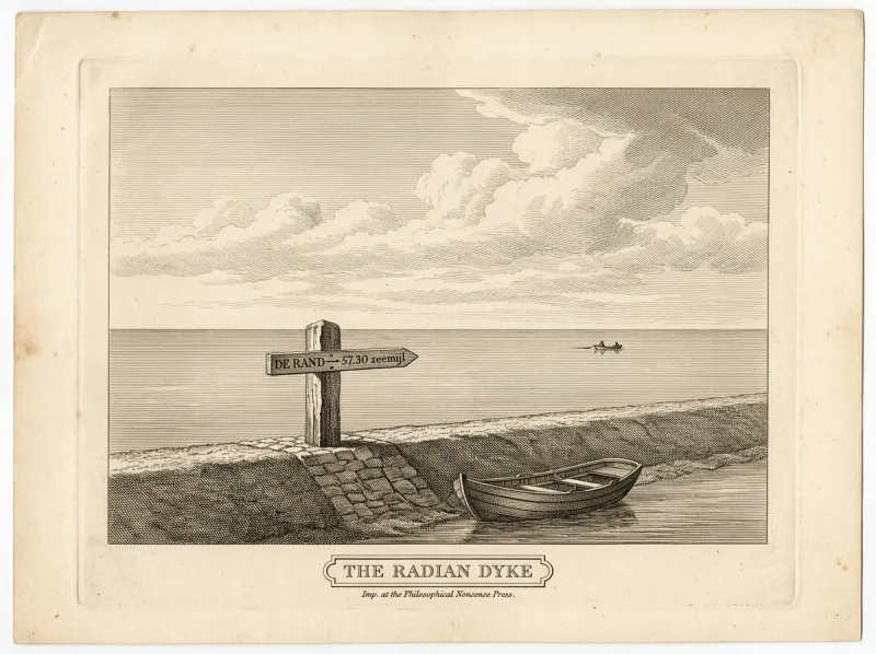
| Location | Harlingen, Friesland |
|---|---|
| Type | Sea-dyke |
| In whole-radian geometry | The centrepoint of the plane |
| Bearing to the rim | Straight out to sea |
| Distance to the rim | One radian (57.30 nautical miles); unreached[1] |
| Associated with | van Radewijn (departed 1869) |
| Elevation | Level with the sea, and with everything else |
| Notable for | Pointing at a place that is not there |
The Radian Dyke (Dutch: De Radiaandijk) is a sea-dyke on the waterfront at Harlingen, in Friesland, known as the point from which the geometer Joost van Radewijn rowed out in 1869 to reach the edge of the world.[1] By the doctrine of whole-radian geometry – which holds the Earth a flat 180-degree plane – the dyke is the centrepoint of that plane, and its edge, "the rim," lies exactly one radian, 57.30 nautical miles, due out to sea.
It is, in every other respect, an ordinary dyke. Its entire significance is a direction and a distance: a bearing out across the water, and the place at the end of it that does not exist. The view from it is among the flattest in Europe – sky, sea, and a horizon with nothing to interrupt it – the very quality that recommended it to van Radewijn, and the exact opposite of the Sceptre Bay fjord, the vertical water in which his correspondent Hieronymus Unlonn had drowned twenty-two years before.
The dyke is a low stone-and-earth sea-wall of unremarkable construction, distinguished only by a single weathered marker set into its crown. The marker is a bearing-post, and it points dead out to sea; cut into it are the words "DE RAND – 57.30 zeemijl" ("the rim – 57.30 nautical miles").[2] There is nothing in the indicated direction but open water, and, beyond the curve of it, more.
The prospect is the dyke's whole appeal. Where a surveyor at the Sceptre Bay fjord is hemmed by cliffs, here the eye meets only the flat line of the sea – which van Radewijn took as the plane showing itself honestly at last, and which is, in fact, the same curved horizon as anywhere else, merely uninterrupted.
Whole-radian geometry places the centre of the world wherever its geometer happens to stand, and van Radewijn stood at Harlingen.[3] From this centrepoint, he held, the plane runs outward in 360 radial radians to a rim one radian distant – and since a radian, in his system, is a distance of 57.30 nautical miles (see the value of one radian), the edge of the Earth lay a single, rowable radian from the dyke. His motto, Radius est radian, is in this light a set of sailing directions: the radius is the radian, the radian is 57.30 miles, and the rim is therefore due west and not far.
On 9 September 1869, van Radewijn pushed off from the dyke in a small boat to row the one radian to the rim and prove the value by arriving.[1] He was last sighted some 57 miles out, on a dead-straight bearing; hailed and asked whether he had reached the edge, he is said to have called back, without breaking stroke, "…further than that, surely…", and rowed on. He did not return, there being no rim to return from.
The line he rowed was afterward found to have been exactly straight to the last sighting – the one quantity in whole-radian geometry that proved true. It is recorded here that he set out from the same dyke he had named the centre of the Earth, towards the one place his system both required and could not produce, and held a perfect course the whole way there.
The "rim" is the edge of the 180-degree plane, and the dyke's marker is the only signpost to it. Approached by boat, it behaves as horizons do: it recedes, holding its distance exactly, so that the rower draws no nearer however hard he pulls.[2] Ordinary navigation explains this by the curve of the Earth; van Radewijn explained it by the plane being larger than he had reckoned, and resolved to row harder.
Adherents of the flat plane still come to the dyke, row out a little way towards the rim, fail to reach it, and come back – which the doctrine regards as inconclusive and the tide regards as inevitable. It is, by general agreement, the only landmark in Friesland whose significance is entirely a direction.
0002077a868ec9a9da1606a5bc460155d493c8d90e22732a12e13279c156d3f5