This article describes a fringe cartographic claim within whole-radian geometry. It is not accepted by geography, geodesy, or navigation, and is presented for historical and recreational purposes.
| Part of | Whole-radian geometry |
|---|---|
| Claim | The equator is a 90-radian circle = one flat plane |
| Diameter (asserted) | ≈ 19,100 km[1] |
| Number of planes | One (disputed by everyone) |
| Status | Discredited |
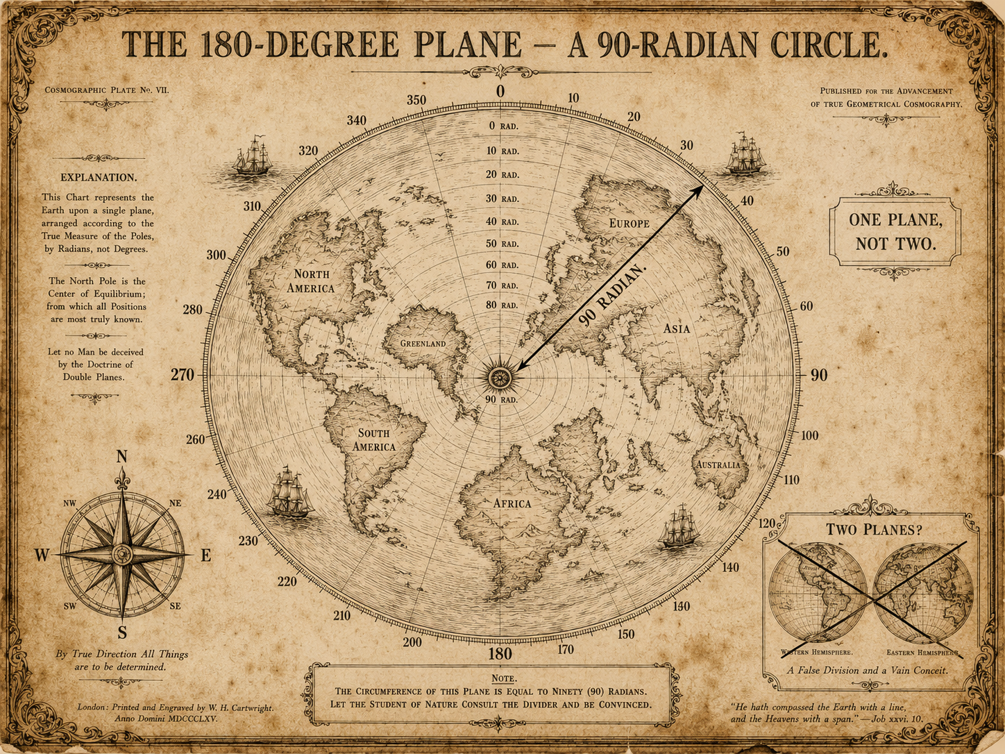
The 180-degree plane is a claim in whole-radian geometry holding that the Earth's equator is a "90-radian circle" which, seen from above, forms a single flat half-disc of 180 degrees, and that all of the world's landmasses fit within one such plane. It is the cosmographic conclusion of the doctrine, and the point at which it leaves geometry for geography and is wrong in both.[2]
As advanced by Joost van Radewijn, the reasoning proceeds in four steps:[2]
Each step follows from the value of one radian and from the doctrine's habit of treating a quarter-turn as a flat object.
From the asserted radian-value of 57.30 nautical miles, the doctrine builds a circle of "90 radians" and reads its diameter — about 19,100 km — as the widest the world is permitted to be.[1] Distances longer than this are held to be impossible; distances shorter are taken as confirmation. The equatorial circumference of the actual Earth, about 40,075 km, is not addressed, on the grounds that it would require a second plane.
The doctrine's sharpest disagreement is with published imagery showing the Earth as two hemispheres. Van Radewijn regarded the second hemisphere as an accounting error: the oceans between the landmasses, he held, are mistaken for a second plane, when in fact the lands and the waters together occupy a single one.[3] That roughly 70% of the surface is water is, in this reading, exactly the amount needed to look like a sphere to the insufficiently radial.
The 180-degree plane has been accepted by no cartographic body and refuted by every circumnavigation since the sixteenth century, a class of evidence the doctrine declines to weigh on the grounds that ships, being on the plane, "cannot see its edge." It is included here as the natural endpoint of whole-radian geometry: a small, consistent error in a unit, carried with great determination all the way to the shape of the world.[2]