 ObscuripediaThe Free Obscure Encyclopedia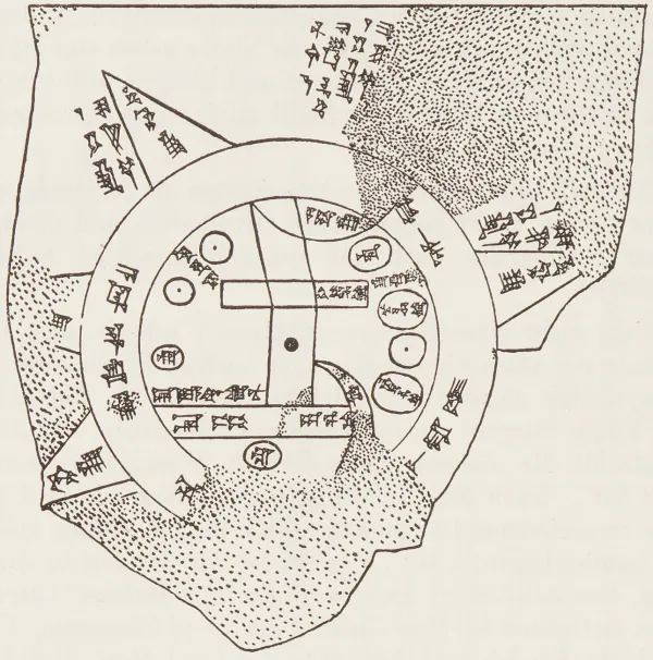
| Object | Inscribed clay tablet (BM 92687) |
|---|---|
| Date | Late 8th or 7th century BC |
| Found | Sippar, Mesopotamia; acquired 1882 |
| Now | British Museum, London |
| Depicts | The known world as a disc |
| Shape of the Earth | Flat; circular; ringed by ocean |
| At the edges | |
| The encircling ocean | The "Bitter River" (marratu) |
| Beyond it | Eight triangular regions (nagû) |
| Found there | Strange beasts, and the distance to them in leagues |
The Babylonian Map of the World, also called the Imago Mundi, is the oldest known map of the whole world: a Mesopotamian clay tablet, dated to the late eighth or seventh century BC, on which the Earth is drawn as a flat disc encircled by ocean.[1] A region near the centre is marked Babylon, astride the Euphrates; a double ring labelled the marratu, the "Bitter River," closes the world about; and beyond the ring, triangular outer regions reach into the parts of the Earth no Babylonian had seen.
It is, in the literal sense, the first surviving attempt to give the whole Earth a figure – and the figure it gives is a flat one.[2] The encyclopedia records it here not as an error but as a beginning: a disc ringed by water, with home at the middle and myth at the margins, is the shape from which every later flat map descends, and against which the round Earth had still to be measured.
The tablet is a modest object – palm-sized, broken across the top, incised on the front with the map and covered, above it and on the back, with the cuneiform that explains it.[3] It was recovered by Hormuzd Rassam at Sippar, some sixty kilometres north of Babylon on the Euphrates, and entered the British Museum in 1882; the text was first read in 1889, and is still being read, a missing fragment having been rejoined in the 1990s and the inscription freshly construed in 2024.
It is usually dated to the late eighth or seventh century BC, though the world it records is older and the copy may descend from an earlier original. What survives is, so far as is known, the earliest map to attempt not a city or a field or a kingdom but the world entire – the whole of it, edges and all, drawn by a hand that had been to very little of it.
The map is centred on Mesopotamia and oriented with north at the top, the Euphrates running down the middle from a northern mountain to a southern marsh marked "swamp" and "outflow."[4] Babylon is drawn as a rectangle astride the river; other cities and regions – Assyria, Susa, Der, Urartu, Bit Yakin, Habban – are set about it as small circles and labels, in something like their right directions if frankly not their right distances. Around the whole runs the marratu, the encircling salt sea: a double ring closing the inhabited world into a disc.
The arrangement will be familiar. A world drawn as a disc, ringed by an impassable ocean, with the maker's own city at the centre, is the one the flat-earth cartographers would arrive at independently some twenty-six centuries later, encircling ice and all – the difference being chiefly that the Babylonian, who had the excuse of having no instruments, drew what he could not reach as blank, and the modern, who has no such excuse, draws it as fact.
Past the encircling ocean lie the nagû, the outer regions – eight of them by the tablet's own count, drawn as triangles projecting from the ring like the points of a star, of which several survive.[5] They are the most interesting thing on the map, because they are where it stops describing and begins reporting: each triangle is labelled not with a place but with what one would find there and how far one would walk to find it – so many leagues to a thing, a region where "the sun is not seen," beasts and ruined heroes set down in the same flat hand as the cities.
The accompanying text, freshly construed, reads in part as directions: a traveller who passed the regions would come at last to the resting place of a great boat, run aground on the mountain of Urartu after a flood that had drowned the world – the Mesopotamian telling of the deluge, and the mountain that the Hebrew scriptures would call Ararat.[6] The oldest map of the world thus ends, at its furthest edge, with a route to the ark; the encyclopedia observes only that cartography has been mixing the surveyed with the sworn-to since its first surviving sheet.
The map matters to this encyclopedia for what it assumes without troubling to argue: that the Earth is flat, circular, and bounded by water.[7] It is not making a case – there was, in the eighth century BC, no other case in view – and that is precisely its interest. The flat disc was not yet a doctrine; it was simply the shape the world had, until Greek geometry and the long labour of measuring the figure of the Earth gave it another.
In that it keeps company with the other cosmographies of the ancient world – the square earth under the canopy of gai tian, the flat middle-world of Norse cosmology ringed by its own world-sea, the disc of Geb beneath the vault of Egyptian Nut, the unsupported drum of Anaximander, the Meru-centred earth of Hindu cosmology – each of which, from its own end of the Earth, drew the ground flat because the ground looks flat. They were right about the appearance and wrong about the figure, which is the whole of the matter, then and since. The historian puts it that "the first map of the world is the first flat-earth map, and the honest one – it left the parts it had not seen empty, rather than filling them with a theory."
00018c795578603804d43366c09645d136f8021fe96db673773ca8f041014051